We do not post much on politics or religion because we think it is extremely difficult to change anyone's mind about political or religious questions. The best thing one can do, we have found, is simply to pose thoughtful questions. Two such questions surfaced in studying Territorial Acquisition by the USA as a reference for land survey and for current land disputes worldwide:
- Are War and Armed Conflict Sane Solutions to Territorial Disputes?
Comment: Historically, in terms of the territorial integrity of peoples, war and armed conflict have been very UNSUCCESSFUL methods in the long-term, so that most nations of the Old World, for example, are still populated by the very same groups of people who populated them millennia ago. So, why war? why armed conflict? when contracts suffice?
- Is the Purchase of Disputed Land a More Sensible Solution? The USA is an example: Louisiana Purchase, Alaska Purchase, etc. Here is a map of U.S. Territorial Acquisitions from Wikimedia Commons:
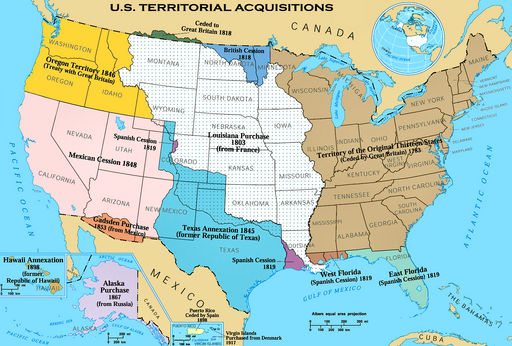
Page URL: http://commons.wikimedia.org/wiki/File%3AU.S._Territorial_Acquisitions.png
File URL: http://upload.wikimedia.org/wikipedia/commons/9/94/U.S._Territorial_Acquisitions.png
Attribution: By United States federal government (en:User:Black and White converted it from JPEG to PNG and retouched it) (National Atlas of the United States [1]) [Public domain], <a href="http://commons.wikimedia.org/wiki/File%3AU.S._Territorial_Acquisitions.png">via Wikimedia Commons</a>
Comment: Having once worked for the State Surveyor's Office of Nebraska, and now posting often about ancient land survey, maps and cartography, it still remains a marvelous revelation that a large share of the United States was purchased outright or obtained by treaty and payment of compensation to stop or reduce war or armed conflict. Without going into the question of the purchase or taking of Indian lands (Native American lands) per se, let us look at some famous purchases:

- Thomas Jefferson's "Louisiana Purchase" in 1803 (ushistory.org) of the Louisiana Territory from Napoleon's France at ca. 4 cents an acre is seen as the greatest real estate deal in history (LOC). This was one of the major events in the making of the United States.
It DOUBLED the size of the United States, and, as written at History.com:
"President Thomas Jefferson commissioned the Corps of Discovery Expedition (1804-06), led by Meriwether Lewis and William Clark, to explore the territory acquired in the Louisiana Purchase, among other objectives."
The Lewis & Clark Expedition, in turn, became a surveying landmark.
- Treaty of Guadalupe Hidalgo 1848 (archives.gov)
"With the defeat of its army and the fall of the capital, Mexico City, in September 1847 the Mexican government surrendered to the United States and entered into negotiations to end the war....
"Under the terms of the treaty negotiated by [Nicholas] Trist, Mexico ceded to the United States Upper California and New Mexico. This was known as the Mexican Cession and included present-day Arizona and New Mexico and parts of Utah, Nevada, and Colorado (see Article V of the treaty). Mexico relinquished all claims to Texas and recognized the Rio Grande as the southern boundary with the United States (see Article V).
The United States paid Mexico $15,000,000 "in consideration of the extension acquired by the boundaries of the United States" (see Article XII of the treaty) and agreed to pay American citizens debts owed to them by the Mexican government (see Article XV). Other provisions included protection of property and civil rights of Mexican nationals living within the new boundaries of the United States (see Articles VIII and IX), the promise of the United States to police its boundaries (see Article XI), and compulsory arbitration of future disputes between the two countries (see Article XXI)."
[and, as for ancient surveying practices]
To carry the treaty into effect, commissioner Colonel Jon Weller and surveyor Andrew Grey were appointed by the United States government and General Pedro Conde and Sr. Jose Illarregui were appointed by the Mexican government to survey and set the boundary. A subsequent treaty of December 30, 1853, altered the border from the initial one by adding 47 more boundary markers to the original six. Of the 53 markers, the majority were rude piles of stones; a few were of durable character with proper inscriptions."
- The Gadsden Purchase in 1853 more or less finalized the continental boundaries of the United States: As written at historytoday.com:
"The Mexican regime was urgently in need of money and for $10 million sold the required strip of territory south of the Gila River, in what is now southern New Mexico and Arizona. It was only a mere 30,000 square miles, about the size of Scotland, but it was the country through which the Southern Pacific Railroad would be built."
- Treaty with Russia for the Purchase of Alaska 1867 (loc.gov), an area of land twice the size of Texas, the largest contiguous U.S. State
"On March 30, 1867, the United States reached an agreement to purchase Alaska from Russia for a price of $7.2 million. The Treaty with Russia was negotiated and signed by Secretary of State William Seward and Russian Minister to the United States Edouard de Stoeckl."
See the Alaska Purchase at the Encyclopaedia Britannica
Text of the Treaty at Bartleby.com, American Historical Documents, 1000–1904. The Harvard Classics. 1909–14. Treaty with Russia (Alaska Purchase) (1867)